
Welcome to “Naijaclass Academy” For Neco 2024 Geography Practical & Objectives Answer (June/July Exam)
Date: Friday, 28th June 2024
Geography (Objective & Practical/ Physical) 10:00am – 12:30pm
——————————
GEO OBJECTIVE
01-10: DABCDCCBBA
11-20: CADECEBCAD
21-30: DACDDEBDAA
31-40: ADDBDDCCBE
41-50: BACDADDEEE
51-60: BBBAEDBBDC
COMPLETED
NUMBER 1
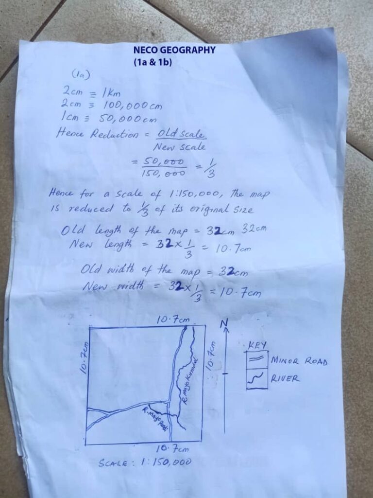
(1c)
(PICK ANY FOUR)
(i) Tourism due to presence of antiquity in the map
(i) Fishing due to presence of rivers
(iii) Transportation due to presence of road
(iv) Trading due to presence of market in the map
(v) Lumbering due to presence of forest
(1d)
It is a dendritic drainage pattern. The main river and its tributaries develop certain patterns from their basin. The subsequent rivers joined the main river called the consequence river at oblique angle. It is a tree-like structure ie like branchesr Of tree.
(2a)
[check the diagram below]
(i) Core: Innermost layer, about 3476km wide all round, consists largely of iron and nickel, divisible into inner and outer core, found in a molten state, reservoir of minerals to the other zones.
(ii) Mantle: middle layer, surrounds the core, about 2897km thick, composed of very dense rocks, rocks are rich in olivine basalt.
(iii) Crust: Lies above the mantle, outer layer, consists of granitic and basaltic rocks, varies in thickness from place to place , divisible into 2-sial and sima, forms soil, sustains life.
(2b)
(PICK ANY FOUR)
(i) Provides a habitat for plants and animals: The surface layer of the Earth’s crust provides a stable and habitable environment for a wide range of organisms. It provides the necessary conditions for life, such as sunlight, water, and nutrients.
(ii) Source of minerals: The surface layer of the Earth’s crust contains a variety of minerals that are essential for human activities. These minera
==≠==================================
(3ai)
Mode Of Formation: Igneous rocks are formed by the cooling and solidification of molten rocks called magma, ejected from beneath the earth’s crust. The magma which results from high temperature and pressure beneath the earth, forces itself towards the earth’s surface through cracks. As the magma moves towards the surface, it comes in contact with lower temperature, hence it cools and solidifies to form Igneous Rocks. A very good example of them are Basalt and Granite.
(3aii)
(i) They are either acidic or basic.
(ii) They are usually hard and impervious.
(iii) They do not contain fossils.
(iv) They do not occur in layers, i.e. they are non-stratified rocks.
(v) Igneous Rocks are crystalline in structures, i.e. they contain crystals.
(vi) They vary in Colour (light or dark).
(3b)
{CHOOSE ANY BEST 4}
(i) Igneous rocks like granite, basalt, and gabbro are used as building materials for their strength and durability.
(ii) Igneous rocks like marble, quartz, and obsidian are used for decorative purposes, such as countertops, flooring, and sculptures.
(iii) Igneous rocks like pumice and basalt are used as abrasives for cleaning and polishing surfaces.
(iv) Igneous rocks are used as aggregate in concrete, asphalt, and road construction.
(v) Igneous rocks like granite and basalt are used as dimension stone for architectural purposes.
==≠==================================
(4a)
Climate is defined as the average weather conditions of a place over a long period of time (35 years).
(4bi)
{CHECK DIAGRAM BELOW}
Convectional Rainfall: Convectional rainfall occurs in the area intensively heated. Hot/Warm air, accompanied by a rise in relative humidity takes place. The rising air becomes saturated and water vapour condenses with cloud being formed quickly. This results im heavy rains, accompanied by thunder and lightning. It is short-lived and characterized by heavy winds, lightning and thunder. Convectional rainfall is always torrential or heavy, accompanied by lightning and thunder.
(4bii)
{CHECK THE DIAGRAM BELOW}
Cyclonic Rainfall: Also Known as Frontal rainfall is caused by meeting of two air masses, which are different in terms of origin and characteristics. Warm, light, moisture ladden air rises above cold and dense air. Ascent of the warn air, cooling takes place and condensation occurs. Cloud formation and precipitation follow. Cyclonic rainfall is characterized by fronts and weather system in mid latitudes.
==≠==================================
(6ai)
River Capture: Also called river piracy or river beheading, refers to two parallel consequent rivers with tributaries separated by a more powerful river and with presence of wind gap. E.g River Ogunpa in Ibadan, Nigeria.
(6aii)
River Rejuvenation: A river is said to be rejuvenated when it is given a new lease of of life or being young again i.e. an extra power of erosion. This happens when the base level of the river falls, either because the land is uplifted or because the level of the sea falls.
(6b)
(i) Solution: Some rock materials dissolve in water and are carried in solution from the upper to lower course of the river.
(ii) Suspension: Here, the lighter particles of solid materials are carried in suspension as the water flows.
(iii) Saltation: In this process, larger particles are moved in series of hops or jumps along the stream bed.
==≠==================================
(7a)
Environment resources refer to any useful item in the environment, or materials and substances that are useful to man.
(7b)
(i) Land Resources.
(ii) Mineral Resources.
(iii) Human Resources.
(iv) Water Resources.
(7c)
Renewable Resources: This are natural resources that are recoverable and that can be replenished over time. They are a sustainable way to meet our energy and material needs.
(7d)
(i) Rain.
(ii) Animal.
(iii) Plant.
(iv) Water.
==≠==================================
(8a)
(i) Land Surveying.
(ii) Remote Sensing.
(iii) Map Digitizing.
(iv) Map Scanning.
EXPLANATION
(i) Land Surveying: Land Surveying is defined as thr process by which measurement of land is made and then represent such measurement by tables, plans or layout for specific purposes.
(ii) Remote Sensing: Remote consists of the main source of digital data for input in a GIS. Remote Sensing (RS) provide extremely useful tools for environmental and natural resources management.
(iii) Map Digitizing: Map Digitizing involves the extraction of data values from graph e.g. in most scientific publication only plots but no data values are published.
(iv) Map Scanning: Existing Maps of various scales containing different type of information about the area of internet in small or big detail. These maps can be scanned, thus the information of these maps can be fed into a GIS and be integrated with other existing information.
(8b)
(i) In Engineering.
(ii) In Planning.
(iii) In Management.
(iv) In Telecommunications.
NECO PRACTICAL & PHYSICAL GEOGRAPHY
(2a)
[check the diagram below]
(i) Core: Innermost layer, about 3476km wide all round, consists largely of iron and nickel, divisible into inner and outer core, found in a molten state, reservoir of minerals to the other zones.
(ii) Mantle: middle layer, surrounds the core, about 2897km thick, composed of very dense rocks, rocks are rich in olivine basalt.
(iii) Crust: Lies above the mantle, outer layer, consists of granitic and basaltic rocks, varies in thickness from place to place , divisible into 2-sial and sima, forms soil, sustains life.
(2b)
(PICK ANY FOUR)
(i) Provides a habitat for plants and animals: The surface layer of the Earth’s crust provides a stable and habitable environment for a wide range of organisms. It provides the necessary conditions for life, such as sunlight, water, and nutrients.
(ii) Source of minerals: The surface layer of the Earth’s crust contains a variety of minerals that are essential for human activities. These minerals include metals, such as iron, copper, and gold, as well as non-metallic minerals, such as sand, gravel, and clay.
(iii) Source of water: The surface layer of the Earth’s crust is home to a variety of water bodies, including oceans, lakes, rivers, and aquifers. These water bodies provide essential resources for human consumption, agriculture, and industry.
(iv) Supports human activities: The surface layer of the Earth’s crust provides a stable foundation for human activities, such as agriculture, construction, and transportation. It also provides scenic beauty and recreational opportunities.
(v) Regulates the Earth’s climate: The surface layer of the Earth’s crust plays a role in regulating the Earth’s climate. It absorbs and reflects solar radiation, and it stores and releases heat.
(vi) Protects the Earth from harmful radiation: The surface layer of the Earth’s crust provides protection from harmful radiation from the sun and other sources. It absorbs and scatters this radiation, reducing its impact on the Earth’s surface.
=====================================================================
(4a)
Climate is defined as the average weather conditions of a place over a long period of time (35 years).
(4bi)
{CHECK DIAGRAM BELOW}
Convectional Rainfall: Convectional rainfall occurs in the area intensively heated. Hot/Warm air, accompanied by a rise in relative humidity takes place. The rising air becomes saturated and water vapour condenses with cloud being formed quickly. This results im heavy rains, accompanied by thunder and lightning. It is short-lived and characterized by heavy winds, lightning and thunder. Convectional rainfall is always torrential or heavy, accompanied by lightning and thunder.
(4bii)
{CHECK THE DIAGRAM BELOW}
Cyclonic Rainfall: Also Known as Frontal rainfall is caused by meeting of two air masses, which are different in terms of origin and characteristics. Warm, light, moisture ladden air rises above cold and dense air. Ascent of the warn air, cooling takes place and condensation occurs. Cloud formation and precipitation follow. Cyclonic rainfall is characterized by fronts and weather system in mid latitudes.
=====================================================================
(6ai)
River Capture: Also called river piracy or river beheading, refers to two parallel consequent rivers with tributaries separated by a more powerful river and with presence of wind gap. E.g River Ogunpa in Ibadan, Nigeria.
(6aii)
River Rejuvenation: A river is said to be rejuvenated when it is given a new lease of of life or being young again i.e. an extra power of erosion. This happens when the base level of the river falls, either because the land is uplifted or because the level of the sea falls.
(6b)
(i) Solution: Some rock materials dissolve in water and are carried in solution from the upper to lower course of the river.
(ii) Suspension: Here, the lighter particles of solid materials are carried in suspension as the water flows.
(iii) Saltation: In this process, larger particles are moved in series of hops or jumps along the stream bed.
=====================================================================
(7a)
Environment resources refer to any useful item in the environment, or materials and substances that are useful to man OR
Environmental Resources in other words are useful things (both living and non-living) occurring naturally within a particular geographical location which are of benefit to man, animals and plants.
(7b)
(i) Land Resources.
(ii) Mineral Resources.
(iii) Human Resources.
(iv) Water Resources.
(7c)
Renewable Resources: This are natural resources that are recoverable and that can be replenished over time. They are a sustainable way to meet our energy and material needs.
(7d)
(i) Rain.
(ii) Animal.
(iii) Plant.
(iv) Water.


I want an anwser practical of geography and objectives answers
Hi Mr Williams Daniel please help me with the answer of geography
O make it fast
Geography exam pin
I want an anwser practical of geography and objectives answers
Hi Mr Williams Daniel please help me with the answer of geography
O make it fast
Geography exam pin
I need the questions please,so that I can read it before tomorrow
I need answers for geography
I need the questions please,so that I can read it before tomorrow
I need answers for geography
pls i need it too
I need it 0
thank for held more peoples
pls i need it too
I need it 0
thank for held more peoples
I also need an answers for geography
I also need an answers for geography
PLS HELP ME WITH ANSWER HURRY UP
SLM thank you I am student
PLS HELP ME WITH ANSWER HURRY UP
SLM thank you I am student
I need the geography question and answers
I need the geography question and answers
i also need it
i also need it
Please I need geography objective answers
Please I need geography objective answers
I need the Geography objective and essay please let me know
I need the Geography objective and essay please let me know
hello every more especialy the helper of student to score accredit during exam thank you so much official.
hello every more especialy the helper of student to score accredit during exam thank you so much official.
hello every one more especialy the helper of student to score accredit during exam thank you so much official.
hello every one more especialy the helper of student to score accredit during exam thank you so much official.
Hi
Hi
hi i need answer for geography
hi i need answer for geography